
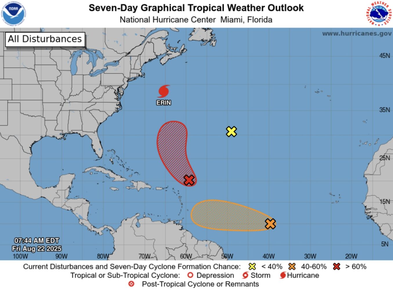
10.30am, 22 August
A tropical wave passing north of the Leeward Islands is unlikely to be any threat to Anguilla, according to this morning’s 8am National Hurricane Center forecast.
The island is now out of the cone of uncertainty, meaning the weather system is very unlikely to move overhead if it turns into a tropical depression.
At Anguilla Focus we keep our core content free for everyone – but our members get access to even more! Click here to join from just $3 per month.
Forecasters have given it a 80% chance of developing into the lowest intensity cyclone in the next 48 hours and 90% in the next seven days.
Meanwhile, the hurricane centre is tracking two other weather systems and Hurricane Erin, which now has sustained winds of 90 miles per hour, continues to travel north to the east of the US.
Earlier updates:
11am, 21 August
A tropical wave a few hundred miles to the east of the Leeward Islands is likely to become a depression as it passes north of the region over the weekend.
This is the lowest strength of cyclone – a large, rotating storm system which is classified by intensity – and is unlikely to pose a threat to Anguilla.
However, the Department of Disaster Management urged residents to “stay informed and prepared” as it continues to keep a “a close eye” on it.
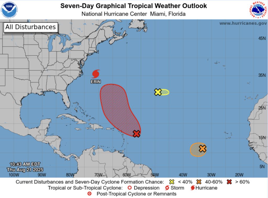
According to an 8am National Hurricane Center forecast, environmental conditions appear conducive for further development of the system.
The chances of a depression forming are 40% over the next 48 hours and 70% – or high – over the next seven days, the centre said.
Meanwhile, two other weather systems are being analysed and Hurricane Erin continues to travel north between the east coast of the US and Bermuda.
4pm, 19 August
Two tropical waves are being “closely monitored” as they move west across the Atlantic Ocean towards the Caribbean region, according to Anguilla’s Department of Disaster Management.
The closest, which is moving at about 20 miles per hour, has a 60% chance of forming a cyclone in the next seven days and a 10% chance in the next 48 hours.
According to a National Hurricane Center forecast at 2pm, “environmental conditions appear conducive for gradual development” and a tropical depression towards the end of the week or weekend.
The second weather system, located south of the Cabo Verde Islands, has a 30% chance of cyclone formation within seven days and within 48 hours.
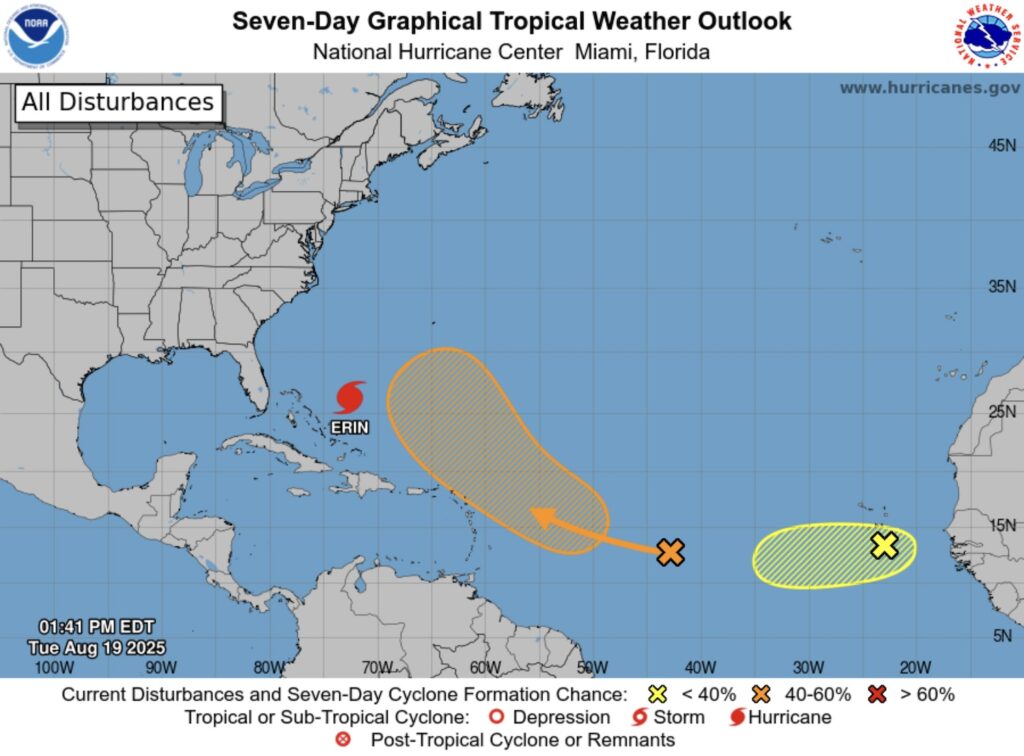
It is moving west at about 15mph and and could encounter a “less favourable environment” towards the end of the week limiting its development at that time, forecasters said.
“While no immediate threat is confirmed, residents should monitor as the first system may bring increased rainfall or gusty winds by the weekend,” the disaster management department stated.
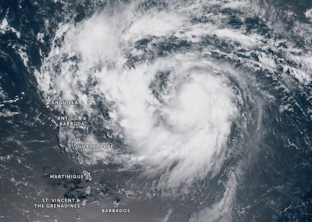
Meanwhile, Hurricane Erin, which is now a Category 2 storm with sustained wind speeds of 105mph, is moving north-northwest away from the Bahamas at 10mph.
2pm, 18 August
A tropical wave moving west across the Atlantic towards the Leeward Islands has a 60% chance of becoming a cyclone in the next seven days, according to forecasters.
A cyclone is a large, rotating storm system and is classified by intensity, ranging from a tropical depression to a tropical storm and finally a hurricane.
The weather disturbance is moving at 20 miles per hour and will approach the Leeward Islands on Friday, a 2pm forecast from the National Hurricane Center said.
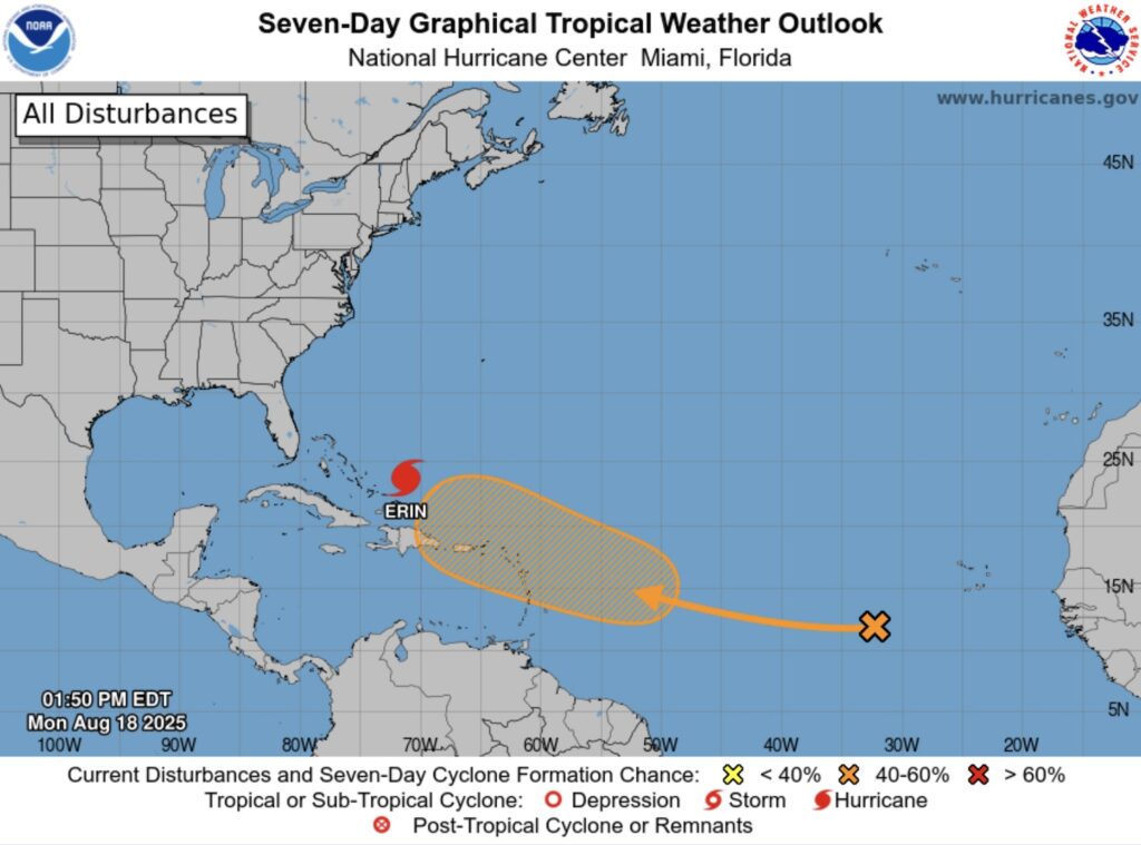
Meanwhile, Hurricane Erin, which is a Category 4 storm with sustained winds of 140mph, is moving slowly west-northwest away from the Turks and Caicos Islands at a speed of 10mph.
Hurricane-force winds extend outward up to 80 miles from the centre and tropical-storm-force winds extend outward up to 230 miles.
The hurricane centre predicts that it will become even larger over the next few days.
9.30am, 17 August
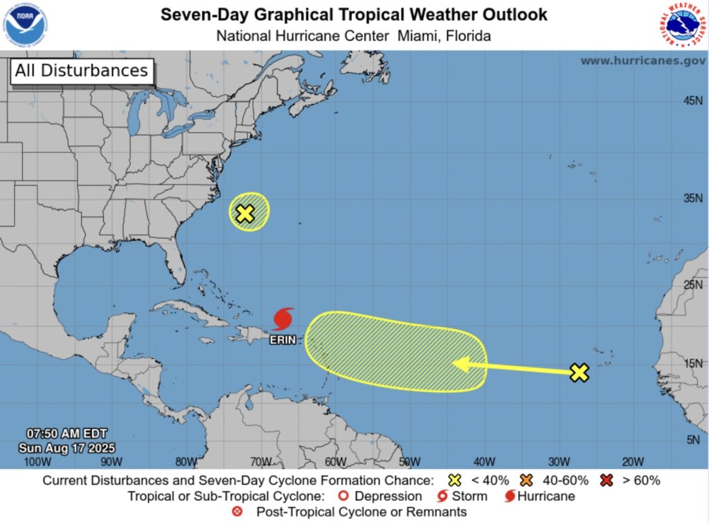
Meanwhile, the National Hurricane Center has reported that a tropical wave has formed to the west of the Cabo Islands in the Atlantic Ocean and is moving in the direction of the Leewards Islands.
The centre’s 8am forecast said it has a 20% chance of forming a cyclone in the next seven days and a 0% chance in the next 48 hours.
11.30am, 16 August
Hurricane Erin, now passing 105 miles north of Anguilla, has strengthened into a ‘catastrophic’ Category 5 storm, with sustained winds of 160mph with higher gusts.
The island’s Tropical Storm Watch has been discontinued but Anguilla’s Department of Disaster Management has warned that heavy rainfall is expected over the weekend.
This may lead to flash floods in low lying areas, along with landslides or mudslides, it said in a notice earlier today. A high surf warning is in effect until midnight.
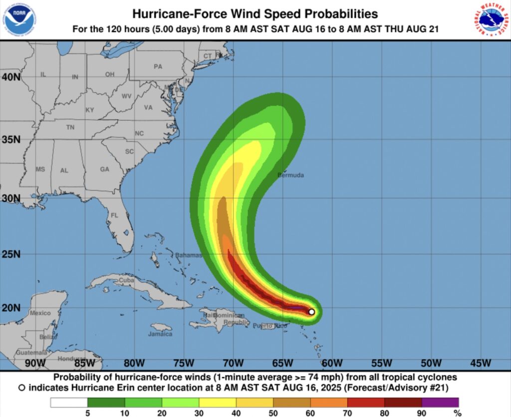
According to its 11.20am forecast update, the National Hurricane Center said that reports from an Air Force Reserve Hurricane Hunter aircraft indicated that Erin has become a Category 5 hurricane.
It has rapidly intensified from a category one storm in just 24 hours.
11.30am, 15 August
Hurricane Erin has formed in the Atlantic to the east of the Caribbean region and is on track to pass north of Anguilla, which is under a Tropical Storm Watch.
In its 11am update, the National Hurricane Center said the storm has increase in strength from a tropical storm and is now has maximum sustained winds of 75 miles per hour with higher gusts.
It is moving west-northwest at 18mph and the centre is forecast to pass the northern Leeward Islands on Saturday morning, 16 August.
Hurricane-force winds extend outward up to 25 miles from the centre and tropical-storm-force winds extend outward up to 115 miles, mainly to the north of the centre.
Erin is expected to become a category three major hurricane with sustained winds of at least 111mph by Saturday evening.
Anguilla’s Department of Disaster Management announced just after 5pm on 14 August that the island had been put under a Tropical Storm Watch.
This means that tropical storm conditions – such as strong winds, heavy rainfall and rough seas – are possible within the 48 hours from the announcement.
12.30pm, 14 August
The northern Leeward Islands – including Anguilla – are likely to experience heavy rainfall, high surf, rip currents and tropical storm-force winds this weekend, according to the latest forecast.
In its 11am update, the National Hurricane Center said people in these areas should monitor the progress of Tropical Storm Erin, which is expected to become a hurricane in the next 24 hours.
The storm is has increased in strength and now has maximum sustained winds of 60 miles per hour with higher gusts.
Tropical-storm-force winds – sustained winds ranging from between 39 and 73mph – extend up to 60 miles from its centre.
It is moving slowly west across the Atlantic Ocean at 17mph towards the Caribbean, but is expected to turn toward the west-northwest tonight.
This will mean that the centre of the storm will pass north of Anguilla over the weekend as it strengthens to become a major hurricane of category three or higher.
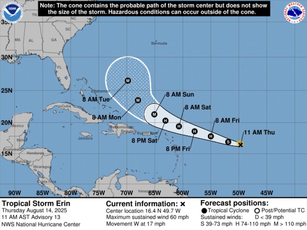
11.30am, 13 August
Tropical Storm Erin is forecast to reach category one hurricane strength between late Thursday, 14 August, and early Friday, 15 August – over 24 hours later than initially expected.
According to the National Hurricane Center, it is then predicted to rapidly strengthen over the weekend to become a category three major hurricane by Sunday morning.
The storm is currently producing maximum sustained winds of 45 miles per hour with higher gusts. Tropical-storm-force winds extend up to 60 miles from its centre.
It is moving slowly west across the Atlantic Ocean at 15mph – substantially slower than the 23mph recorded on Tuesday.
The hurricane centre at 11 am said: “On the forecast track, the centre of Erin is likely to move near or just north of the northern Leeward Islands over the weekend.”
Anguilla has a 30 to 40% chance of experiencing tropical storm force winds, according to the forecast.
Meanwhile, swells which “are likely to cause life-threatening surf and rip current conditions” will begin affecting portions of the northern Leeward Islands by the weekend.
11am, 12 August
Anguilla faces a 30 to 40% chance of experiencing tropical storm force winds from Friday, 15 August, according to the latest National Hurricane Center forecast.
Tropical Storm Erin, which currently has maximum sustained winds of 45 miles per hour, is expected to become a hurricane by midweek as it travels “quickly” west across the Atlantic Ocean.
While it is expected to track north of the Caribbean over the weekend, updated predictions indicate that winds from the weather system could affect the northern Leeward Islands.
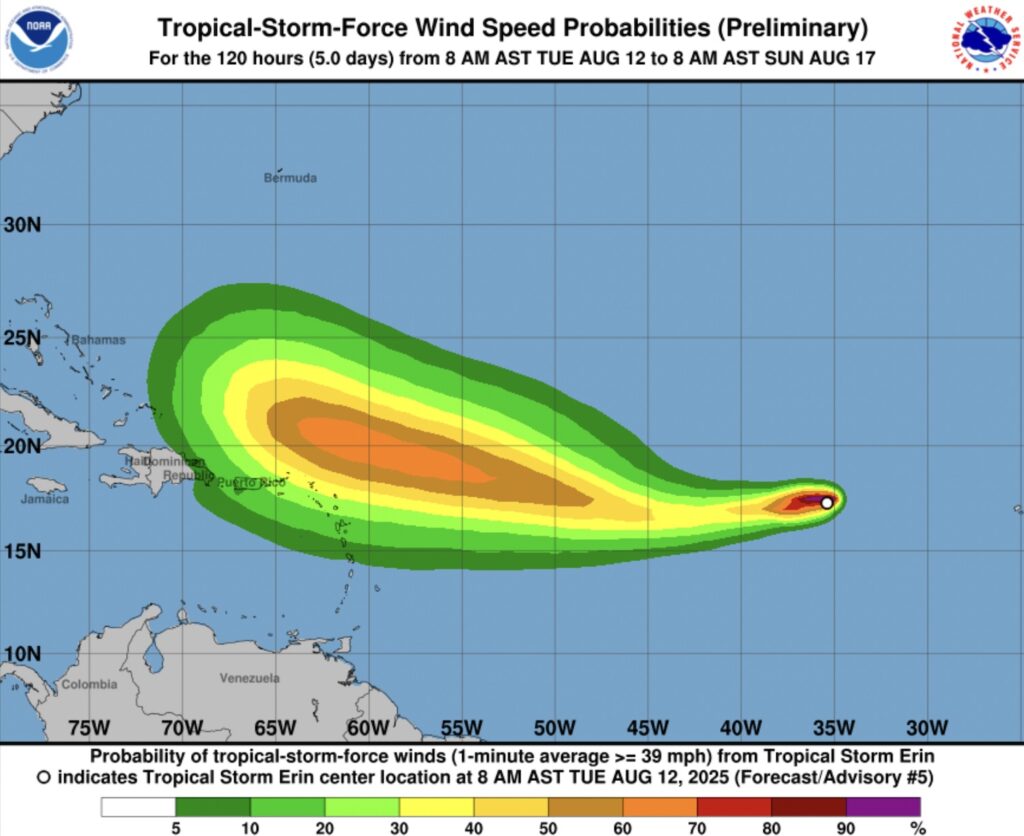
The storm is moving at 23mph, according to an 11am forecast, and winds are currently predicted to reach the Caribbean from about midday on Friday.
“Although it is still to early to know exactly what impact Erin might bring to the northern Leeward Islands, the Virgin Islands and Puerto Rico, the risk has increased for Erin to move closer to these islands over the weekend.
“Interests there should monitor the progress of this storm,” the hurricane centre said.
1pm, 11 August
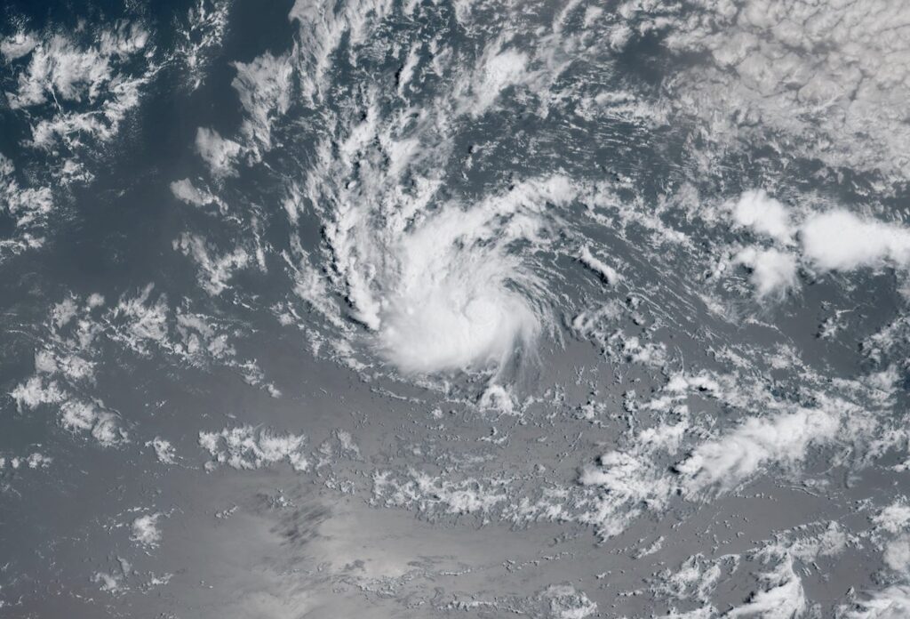
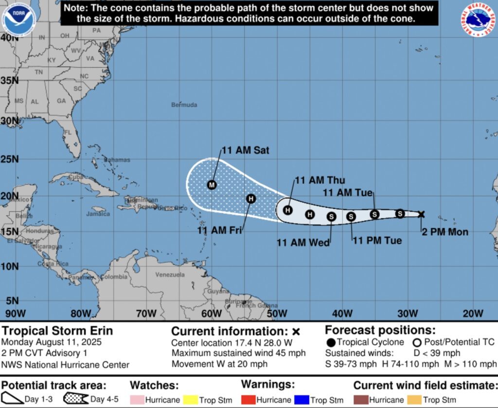
Tropical Storm Erin has developed just west of the Cabo Islands in the Atlantic Ocean and is expected to intensify into a hurricane by midweek.
An 11am forecast from the National Hurricane Center, said the weather system now has maximum sustained winds of 45 miles per hour with higher gusts.
It is moving west at a speed of 20mph and tropical-storm-force winds are extending outward up to 35 miles from its centre.
“The intensity forecast in the short-term is a little tricky,” the forecast said.
“The earlier scatterometer data indicate the system has a small circulation which could be prone to rapid intensity changes, either up or down.”
The forecast suggests that it may develop into a hurricane late on Wednesday and into a major hurricane of category three or above on Saturday morning.
The projected path of the storm does not indicate that Anguilla will be in its direct path, though at this stage its eventual track remains highly uncertain.
9am, 11 August
An area of low pressure just west of the Cabo Islands in the Atlantic Ocean has a very high likelihood of developing into a tropical cyclone within the next 48 hours.
An 8am forecast from the National Hurricane Center said shower and thunderstorm activity has persisted and continues to show signs of organisation.
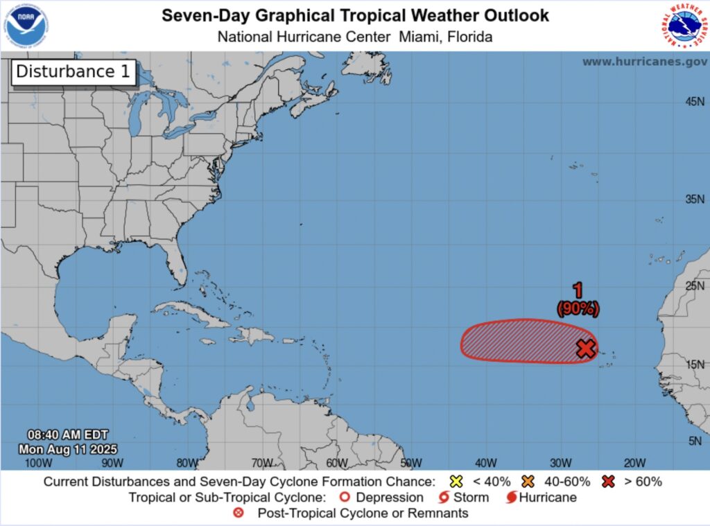
“If these structural trends continue, the system is likely to become a tropical depression or storm, possibly as soon as later this morning,” it continued.
The system is now forecast to move towards the Caribbean, though at this early stage its eventual track remains highly uncertain.
Regardless of development over the next couple of days, it is expected to move westward to northwestward at 15 to 20 miles per hour, the centre said.
12pm, 10 August
A weather disturbance off the west coast of Africa has a high likelihood of developing into a tropical cyclone over the next seven days as it moves west.
Its path remains uncertain, though the National Hurricane Center forecast at 9.35am suggested Anguilla may be at the southern boundary of its projected route.
Weather experts from the centre said satellite-derived wind data had indicated that a low pressure system had formed with maximum winds of about 35 miles per hour.
“Although the associated shower and thunderstorm activity still lacks some organisation, only a small increase in the organisation could lead to the formation of a tropical depression,” it said.
The report said there is a 40% chance of this happening in the next 48 hours and an 80% probability in the next week.
“Even if a tropical depression does not form over the next day or so, environmental conditions appear conducive for later development,” it continued.
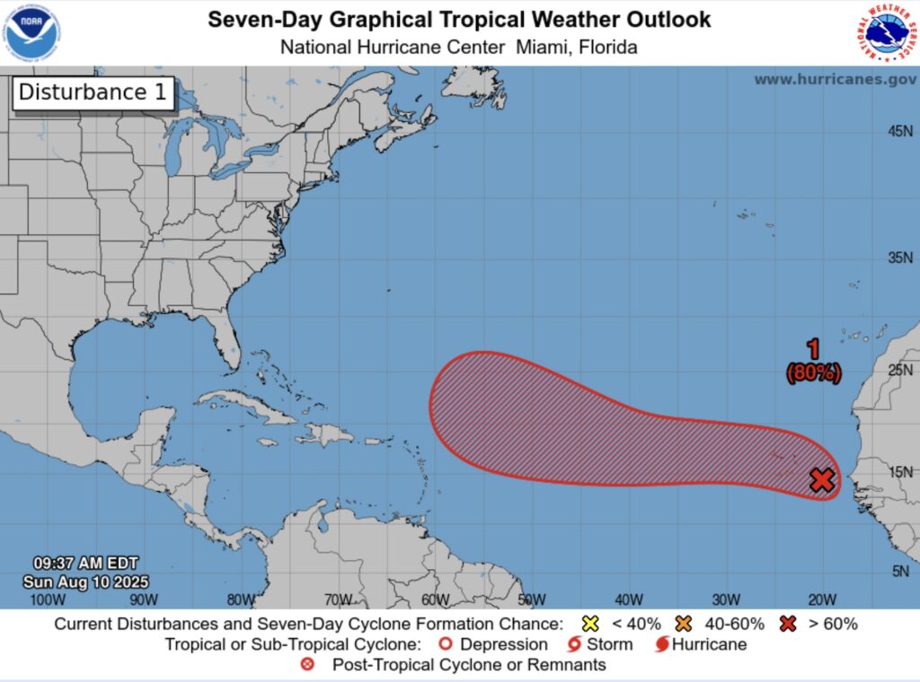
“A tropical depression is likely to form by the middle to latter portion of the week while moving west-northwestward at 15 to 20mph across the eastern and central tropical Atlantic.”
In May, the National Oceanic and Atmospheric Administration (NOAA) forecast increased storm risk this Atlantic hurricane season which runs from from June to November.
It predicted between 13 and 19 named cyclones with winds of 39 miles per hour or higher, with six to 10 forecast to become hurricanes with winds of 74 mph or higher.
Of those, the agency is expecting three to five to be major hurricanes, of category three, four or five, with winds of 111 mph or higher.
Information on how to prepare for a hurricane is available from the US National Weather Service here.
Visit the US National Hurricane Center for the latest updates on this and other weather disturbances at nhc.noaa.gov