
11am, 10 October
Tropical Storm Jerry has left Anguilla largely unscathed after the centre of the storm passed just north of the island overnight.
The Department of Disaster Management lifted the tropical storm warning just after 7.30am as the weather system tracked northwest away from the island.
However, it advised that moisture and instability will bring increased chances of showers and thunderstorms today and tonight.
“Expect periods of heavy rainfall, gusty winds and possible localised flooding,” the department said.
Members of Anguilla Focus get exclusive discount codes for accommodation, travel and activities! Click here to join from just $3 per month.
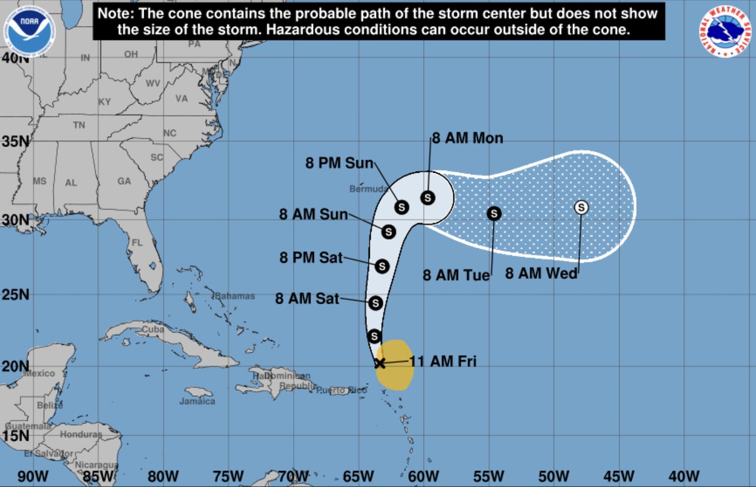
According to the National Hurricane Center in its 11am forecast, the tenth named storm of the Atlantic hurricane season has maximum sustained winds of 50 miles per hour with higher gusts.
It is moving west-northwest at 16mph, with tropical storm force winds extending 185 miles from the centre, and is no longer forecast to strengthen into a hurricane.
Earlier updates:
8.30am, 9 October
Tropical Storm Jerry is expected to pass just north of Anguilla later this evening and into Friday morning bringing strong winds and heavy rain, according to the latest forecast.
The Department of Disaster Management issued an advisory yesterday urging residents to monitor updates closely and review their preparedness plans.
The island is currently under a tropical storm watch, meaning tropical storm conditions are expected in the next 48 hours.
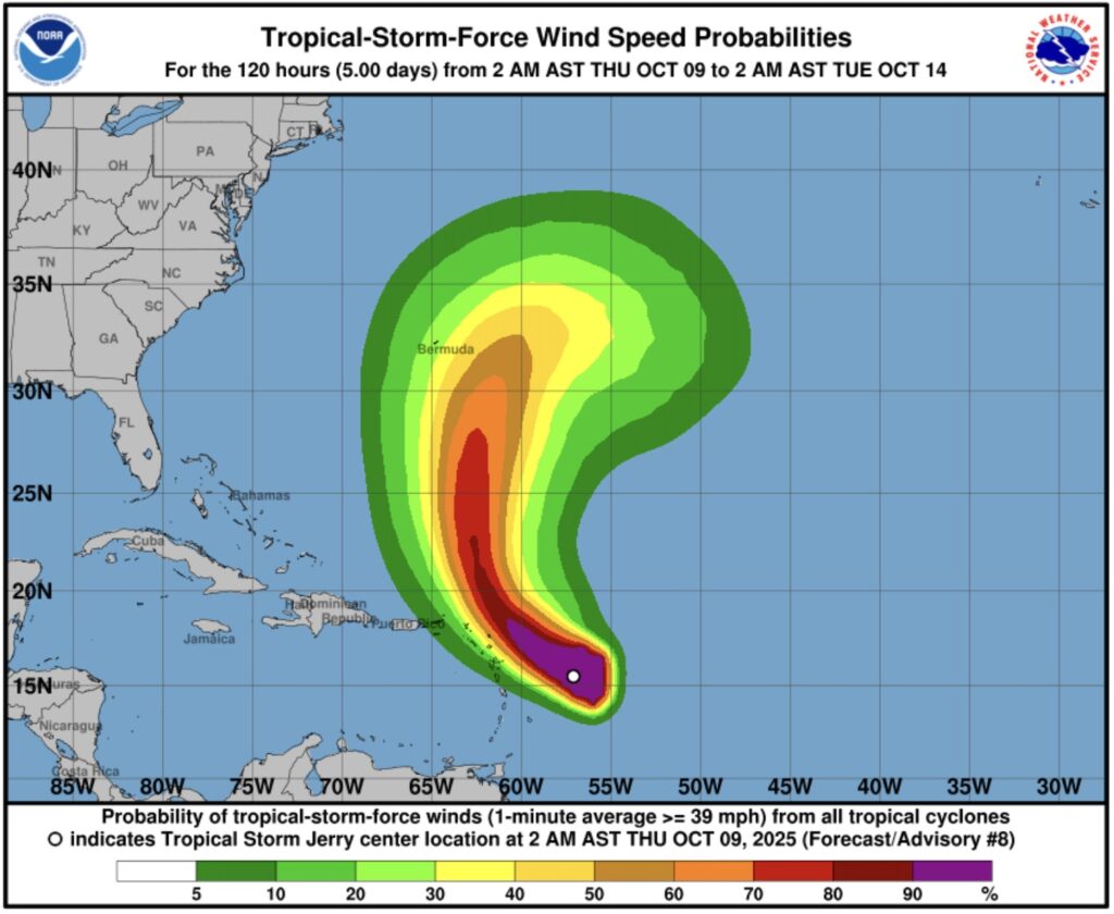
According to the National Hurricane Center in its 8am forecast, the tenth named storm of the Atlantic hurricane season has maximum sustained winds of 65 miles per hour with higher gusts.
It is moving west-northwest at 20mph, with tropical storm force winds extending 175 miles from the centre, and is forecast to strengthen into a hurricane tomorrow afternoon.
“Through Friday, two to four inches of rain with local storm total maxima to six inches are expected across the Leeward and Virgin Islands,” the centre said.
“This rainfall brings a risk of flash flooding, especially in urban areas and in steep terrain.”
9am, 8 October
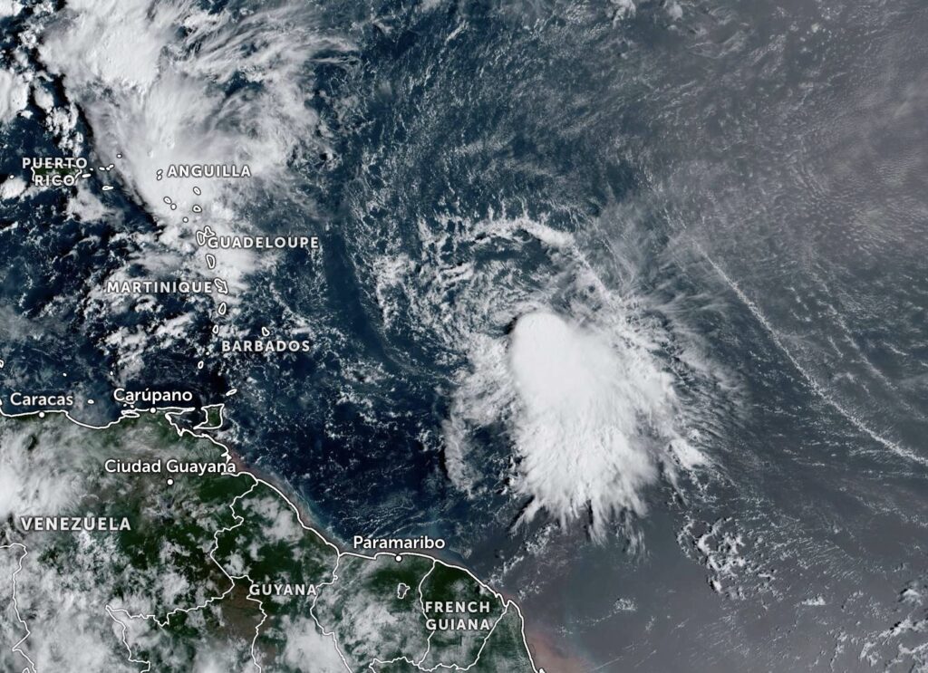
Anguilla is now under a tropical storm watch as Tropical Storm Jerry tracks towards the northern Leeward Islands.
The Department of Disaster Management issued an advisory at 5pm yesterday urging residents to monitor updates closely and review their preparedness plans.
“A tropical storm watch means that tropical storm conditions are expected somewhere within the watch area within 48 hours,” it read.
The tenth named storm of the Atlantic hurricane season which is moving west-northwest at 23 miles per hour is forecast to strengthen into a hurricane by tomorrow.
According to the National Hurricane Center in its 8am forecast, the weather system has maximum sustained winds of 50mph with higher gusts.
Tropical storm force winds are extending 125 miles from the centre.
“Heavy rainfall will impact portions of the Leeward Islands on Thursday into early Friday, which could result in flash flooding, particularly in areas of high terrain,” the centre said.
11.30am, 7 October
The tenth named storm of the Atlantic hurricane season – Tropical Storm Jerry – has formed in the central tropical Atlantic.
It is forecast to strengthen into a hurricane within the next 24 hours before tracking toward the northern Leeward Islands.
In its 11am forecast, the National Hurricane Center reported that the storm has maximum sustained winds of 45 miles per hour and is moving quickly west at 24mph.
Tropical-storm-force winds are extending outward up to 140 miles from the centre.
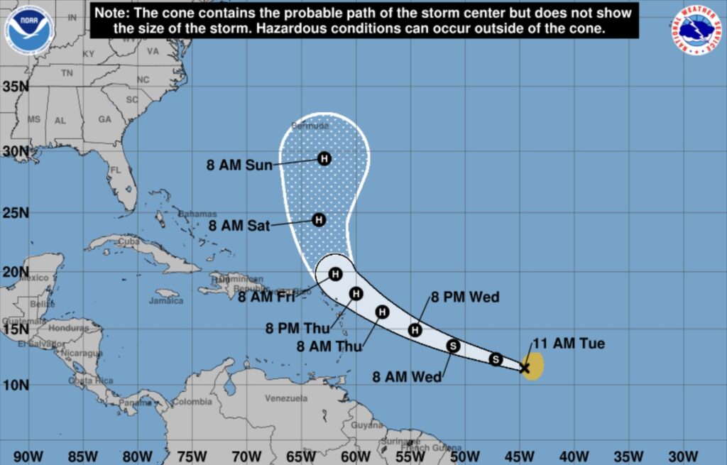
The centre predicts the storm will become a hurricane by 8pm on Wednesday and travel north of the Leeward Islands around 8am on Friday.
Swells generated by the storm are expected to reach the Leeward Islands on Thursday and are likely to cause life-threatening surf and rip current conditions.
Anguilla is within the forecast cone of uncertainty – the area that shows where the centre of the storm could track in the coming days.
“Interests in the northern Leeward Islands should monitor the progress of Jerry as Tropical Storm Watches could be required later today or tonight,” the hurricane centre said.
9am, 7 October
An area of low pressure tracking in the direction of Anguilla is highly likely to develop into a tropical depression over the next 48 hours, according to weather forecasters.
In its 8am forecast, the National Hurricane Center reported that showers and thunderstorms in association with the weather system are becoming better organised.
“If these trends continue advisories are likely to be initiated on a tropical depression later today,” the centre said.
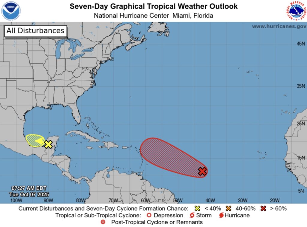
The system is expected to move quickly west-northwestward across the central tropical Atlantic, and then move near or north of the northern Leeward Islands on Thursday and Friday.
The National Hurricane Center said that interests there – including in Anguilla – should monitor the progress of the system.
It added that there is a 90% chance of a tropical depression forming within 48 hours.
In a Facebook post on 6 October, Anguilla’s Department of Disaster Management said: “Stay tuned for updates, and ensure your hurricane plans are in place.”
8.30am, 6 October
A low altitude tropical wave travelling across the Atlantic is likely to develop into a tropical depression within the next few days, according to weather experts.
In its 8am forecast, the National Hurricane Center reported that a broad area of low pressure is producing disorganised showers and thunderstorms.
The weather system is moving “quickly” west-northwestward across the central tropical Atlantic and is expected to approach the northern Leeward Islands in the latter part of this week.
“Environmental conditions appear generally conducive for gradual development of this system and a tropical depression is likely to form within the next few days,” the forecast read.
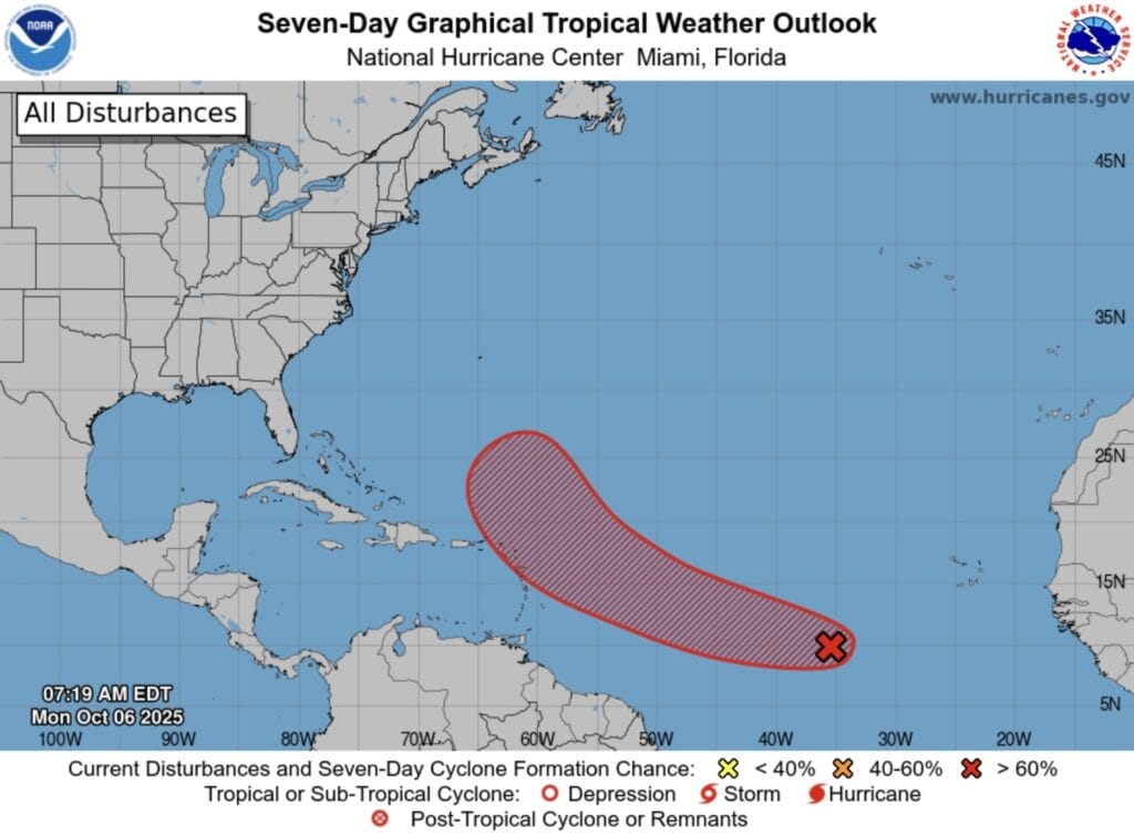
The National Hurricane Center said that interests there – including in Anguilla – should monitor the progress of the system.
It added that there is a 50% chance of a tropical depression forming within 48 hours, increasing to 70% over the next seven days.
In a Facebook post on 5 October, Anguilla’s Department of Disaster Management said: “Anguilla remains in the cone of uncertainty; residents should continue to monitor the approach of this system.”
The Department of Disaster Management advises the public stay connected through its official WhatsApp channel. Click here for more information.
Information on how to prepare for a hurricane is available from the US National Weather Service here.
A list and map of hurricane shelter locations can be found on the Anguilla Red Cross site here.